Toronto’s skyline transformation is not just a condo boom; it is the physical result of a deliberate, often contentious, urban planning strategy that prioritized rapid densification over holistic community design.
- The city adapted—and often diluted—the “Vancouverism” model of tower-podium living to fit its unique geographical and historical context.
- Development was accelerated by a flexible approach to heritage, leading to compromises like “facadism” instead of the strict preservation seen in UNESCO-designated cities.
Recommendation: To truly understand the city, look beyond the glass towers and observe the tension at street level—in the wind tunnels, the hidden public parks, and the neighbourhoods that have resisted the change.
To stand on the Toronto Islands and look back at the city is to witness a decade of explosive growth made manifest in steel and glass. The skyline of today is almost unrecognizable from that of 2010, a dense forest of towers that has fundamentally altered the city’s silhouette. The common explanation points to a relentless condo boom, fuelled by investment and population growth. While true, this observation only scratches the surface. It describes the symptom, not the diagnosis. It sees the buildings but misses the architectural and political narrative they represent.
The real story of Toronto’s vertical ascent is far more complex. It’s a tale of competing urban planning philosophies, economic pressures, and political compromises. It’s about the deliberate importation of one city’s design gospel—”Vancouverism”—and its subsequent mutation in a different urban environment. This transformation wasn’t an accident; it was the result of a series of conscious decisions that prioritized hyper-densification, often at the expense of heritage and the human-scale public realm. The very fabric of the city, from the preservation of Victorian industrial sites to the shadows cast on downtown parks, tells this story.
This analysis will deconstruct the forces that have sculpted Toronto’s modern identity. We will move beyond the simple narrative of “more condos” to explore the underlying architectural templates, the economic logic behind heritage compromises, and the tangible impacts on street-level life. By understanding the philosophies, the policies, and the public pushback, we can begin to read the skyline not just as a collection of buildings, but as a chronicle of a city in the midst of a profound and ongoing identity crisis.
This article examines the key drivers and consequences of Toronto’s architectural transformation. The following sections will guide you through the planning models, development pressures, and human-scale impacts that have defined the city’s last decade.
Summary: Decoding a Decade of Architectural Transformation in Toronto
- Why Did Toronto’s Distillery District Transform From Industrial Wasteland to Hub?
- How Did the “Vancouverism” Urban Design Model Influence Global Cities?
- Why Does UNESCO Heritage Status Change Property Values in Old Districts?
- Identifying Frank Gehry’s Influence: What to Look for in the AGO Building?
- The “Shadow Impact” Risk: How Skyscrapers Affect Street-Level Parks
- Where to Find the Best Free Rooftop Views in Downtown Montreal?
- Boat Tour vs. Helicopter: What is the Best Way to See the Skyline?
- Dining in Toronto: How to Explore Kensington Market Like a Local?
Why Did Toronto’s Distillery District Transform From Industrial Wasteland to Hub?
The sheer scale of Toronto’s construction boom provides the context for its transformation. A staggering statistic reveals that as of 2023, Toronto leads North America with 220 construction cranes, a visual testament to the intense development pressure. This boom did not happen in a vacuum; it required successful templates for large-scale regeneration. The revitalization of the Distillery District stands as the seminal case study in this urban narrative. Once the derelict site of the Gooderham & Worts distillery, its transformation into a vibrant pedestrian-only village of boutiques, galleries, and residences became a powerful model for the city.
The success wasn’t accidental. It was the result of a visionary public-private partnership that leveraged unique zoning variances and strict heritage preservation requirements. Instead of demolishing the Victorian industrial architecture, developers were tasked with integrating it into a modern commercial and residential hub. This approach created a powerful sense of place that was both historically authentic and commercially viable, a stark contrast to the generic glass towers rising elsewhere.
Case Study: The Distillery District’s Public-Private Partnership Model
The Distillery District’s transformation set a crucial precedent for future developments in Toronto. By proving that preserving a neighbourhood’s industrial character could be a massive commercial asset, it created a template for later regeneration projects. The model, combining the preservation of Victorian industrial architecture with contemporary commercial and residential uses, directly influenced the revitalization of the King-Spadina area and laid the groundwork for massive mixed-use projects like The Well and the upcoming East Harbour development.
Ultimately, the Distillery District demonstrated that large-scale development could coexist with heritage preservation, creating a highly desirable—and profitable—urban experience. This curated blend of old and new became the aspirational blueprint for many of the large-scale projects that would come to define the skyline over the next decade.
How Did the “Vancouverism” Urban Design Model Influence Global Cities?
As Toronto grappled with its growth spurt, it looked west for a solution. The city imported and adapted “Vancouverism,” an urban design philosophy famous for creating livable, high-density downtown cores. This model is characterized by a specific architectural form: a mixed-use podium of 3-7 stories that lines the street, with a slender residential tower set back above it. The goal is to maintain an active, human-scale street life while accommodating significant population growth. Research on Toronto’s adaptation of these guidelines highlights the technical specifications, such as a preference for 750 m² floor plates and 25m tower separation to ensure light and air.
However, Toronto’s application of Vancouverism was a distinct mutation, not a direct copy. As critic James T. White noted in a study on the topic, Toronto’s context is fundamentally different. Unlike Vancouver, which is constrained by mountains and the ocean, Toronto’s flat geography and its network of established Victorian streetscapes meant that the tower-and-podium model was applied more sporadically and with greater variation. The result was a skyline where the “rules” of tower placement and base integration were often bent.
A prime example of this adaptation is the CityPlace development. Built by the same developer who pioneered the model in Vancouver, Concord Pacific, Toronto’s version became a cautionary tale. While the density was successfully increased, critics argue that it was a “poor imitation” that failed to replicate the high-quality public realm and vibrant streetscape of its Vancouver counterparts. It achieved density but at the cost of the very livability the philosophy was meant to ensure.
This “Toronto-fied” version of Vancouverism explains much of the modern skyline: a landscape of countless tower-podium buildings that follow a general template but often lack the cohesive, pedestrian-focused planning that made the original concept so successful. It was a philosophy of densification adopted as a tool for growth, but often stripped of its community-building soul.
Why Does UNESCO Heritage Status Change Property Values in Old Districts?
A crucial factor enabling Toronto’s hyper-development is what the city lacks: a UNESCO World Heritage Site designation. Unlike cities such as Quebec City or Lunenburg, whose historic cores are protected by strict international standards, Toronto has no such constraints. This absence has allowed for a much more aggressive and flexible approach to redevelopment, where the preservation of history is often a negotiation rather than a mandate. The result is a skyline with over 108 completed skyscrapers over 150m, a scale of development that would be impossible in a UNESCO-protected zone.
In place of wholesale preservation, Toronto has mastered the art of compromise, most controversially through the practice of “facadism.” This involves demolishing an entire heritage building except for its front wall, which is then integrated into the base of a new, modern tower. It is the physical manifestation of the city’s central conflict: a desire to acknowledge history while bowing to the immense economic pressure for densification. While critics decry it as creating architectural ghosts, developers see it as a pragmatic solution that allows them to build while technically meeting heritage requirements.
The economic logic is powerful. While properties within designated Heritage Conservation Districts (HCDs) see higher values due to their protected character and charm, the potential profit from building a 50-story condo tower on the same land is exponentially greater. Facadism became the loophole that allows developers to capitalize on a site’s location without being fully constrained by its history. This practice explains the surreal sights throughout downtown, where the ornate brick face of a 19th-century warehouse serves as the lobby for a gleaming glass skyscraper.
Identifying Frank Gehry’s Influence: What to Look for in the AGO Building?
Perhaps no single architect’s work better illustrates the shift in Toronto’s priorities than Frank Gehry’s. His 2008 renovation of the Art Gallery of Ontario (AGO) is a masterclass in contextual, human-scale design. Rather than an imposing monument, Gehry created a building that engages with the street. The long, undulating glass-and-wood facade of the Galleria Italia feels more like a covered public promenade than a fortress of high culture, inviting the city in. The building’s power lies in its sculptural forms and its thoughtful integration with the existing neighbourhood.

As you can see, the focus is on materiality, light, and creating a dynamic experience at eye level. The titanium curves and flowing glass are designed to be appreciated from the sidewalk, reflecting the sky and the life of the street. However, the evolution of Gehry’s own work in the city tells the story of Toronto’s changing architectural appetite. His upcoming “Forma” towers, a pair of shimmering residential skyscrapers, represent a pivot from horizontal integration to vertical ambition.
From the horizontal, street-integrated design of the AGO renovation to the shimmering verticality of his upcoming ‘Forma’ skyscrapers – this shift says everything about Toronto’s changing architectural priorities from 2008 to today.
– Lance Berelowitz, Canadian Architecture Review
This evolution from a street-focused cultural institution to ultra-luxury vertical living, designed by the same celebrated architect, is a microcosm of the city’s broader transformation. It signals a move away from prioritizing ground-level public engagement towards prioritizing height, views, and density. The influence of “starchitects” has shifted from creating public landmarks to branding private residences in the sky.
The “Shadow Impact” Risk: How Skyscrapers Affect Street-Level Parks
The relentless vertical growth of Toronto has not come without a cost, much of which is paid at street level. One of the most significant and debated consequences is the “shadow impact.” As towers climb higher and closer together, they cast vast shadows that can plunge public parks, sidewalks, and plazas into darkness for large parts of the day. This has a direct impact on the usability and enjoyment of green spaces, making them colder, less inviting, and less viable for plant life.
Beyond shadows, the clustering of towers creates another tangible problem: wind tunnels. The smooth, flat facades of skyscrapers channel and accelerate wind, leading to blustery, unpleasant conditions at ground level. In fact, City of Toronto studies show that tower clusters have increased ground-level wind speeds by 40% in some areas. This environmental side-effect further degrades the pedestrian experience, turning a simple walk through the city’s core into a battle against the elements.
The city is now trying to retroactively address these problems. The proposed Rail Deck Park is perhaps the most ambitious and telling example. This plan aims to build a 21-acre park over the active rail corridor in the heart of the condo boom, a direct response to the massive parkland deficit created by decades of intense development. This $1.7 billion project is, in essence, an attempt to surgically insert a green lung into an area that was developed with a single-minded focus on residential density, largely ignoring the need for corresponding public amenities.
The need for a project like Rail Deck Park is a clear admission that the previous development model was incomplete. It highlights the immense challenge and cost of trying to correct the negative externalities of hyper-densification after the fact.
Where to Find Hidden Public Spaces in Toronto’s Vertical City?
In response to the growing canyon-like environment of the downtown core, a new type of public space has emerged, born from negotiation between the city and developers: Privately Owned Publicly-Accessible Spaces, or “POPS.” These are amenities—such as plazas, rooftop terraces, or indoor gardens—that are built and maintained by private developers on their properties but are legally required to be open to the public. They represent a crucial, if often hidden, component of the city’s public realm.
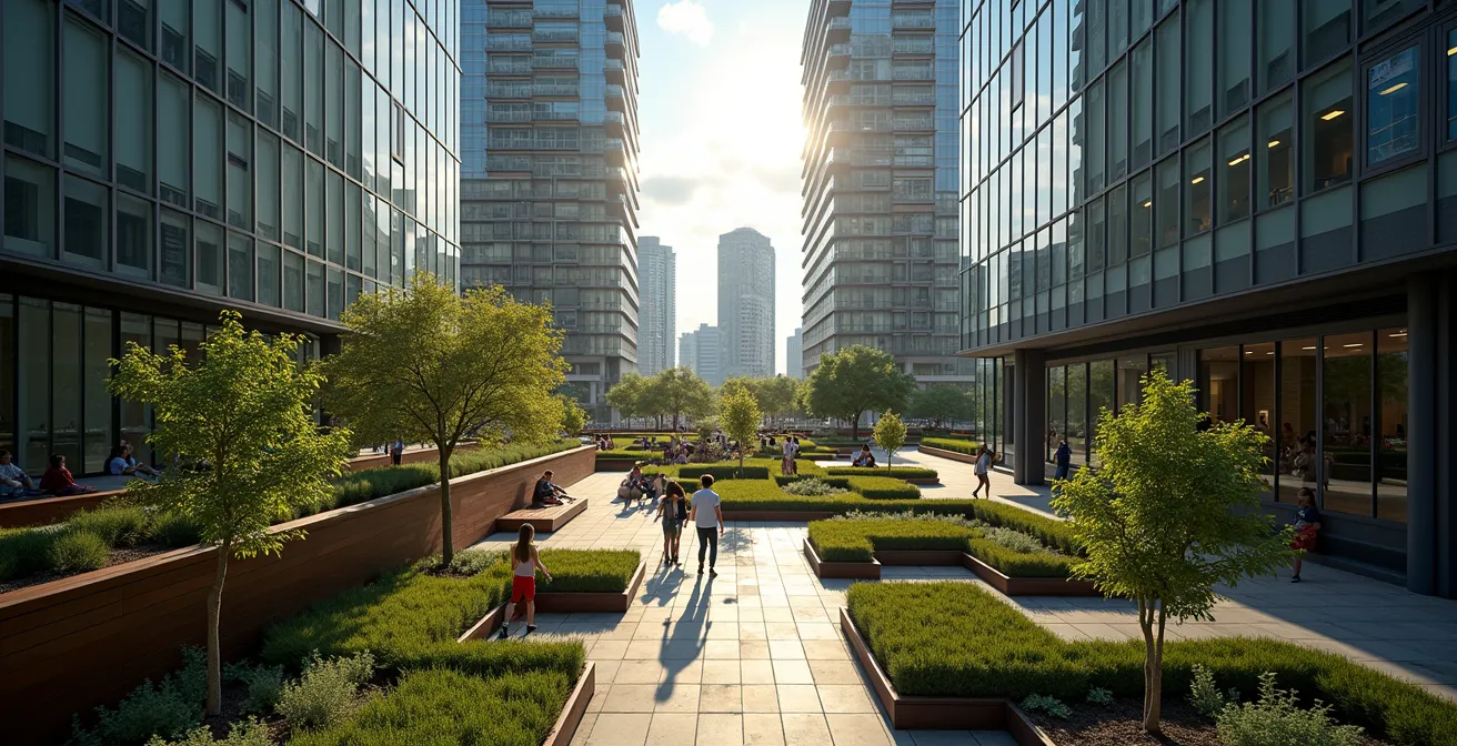
As this aerial view suggests, these spaces are often tucked away or elevated, existing as green oases amidst a concrete and glass jungle. They are a direct concession made by developers in exchange for zoning allowances, such as permission to build higher or denser than normally permitted. For the urban explorer, discovering these POPS can feel like finding a secret garden. They offer a quiet respite from the bustling city and often provide unique, framed views of the very towers that surround them.
Finding these spaces is key to appreciating the layered nature of modern Toronto. They are a testament to the ongoing struggle to carve out human-scale experiences within a landscape increasingly dominated by private interests. For those willing to look, they offer a different perspective on the city. Some notable POPS include:
- Cloud Gardens Conservatory: An elevated park and glass pavilion nestled between towers at Richmond and Bay, offering protected views even in winter.
- CIBC Square Park: A massive new elevated park that bridges the rail corridor, connecting two major office towers and providing significant public green space.
- One York Street Rooftop Terrace: A publicly accessible space at the PATH level that offers surprising views of the harbour and surrounding density.
- Commerce Court Courtyard: An interior courtyard that provides dramatic, framed upward perspectives of the iconic towers of the Financial District.
These spaces are a negotiated truce in the battle for the public realm, representing both the success of city planners in securing public benefits and the pervasive influence of private development on urban life.
Key Takeaways
- Toronto’s skyline is not an accident but the result of specific planning models like an adapted “Vancouverism” and compromises like “facadism.”
- The transformation was driven by a public-private partnership model perfected in projects like the Distillery District, prioritizing regeneration and density.
- This rapid growth has had tangible negative consequences, such as wind tunnels and park shadowing, which the city is now trying to correct at great expense.
Boat Tour vs. Helicopter: What is the Best Way to See the Skyline?
To truly appreciate the architectural narrative of Toronto, one must view it from multiple perspectives. Each vantage point—from the water, the air, or the ground—tells a different part of the story of the city’s evolution. Choosing how to see the skyline is choosing which story you want to hear. A boat tour from the Islands, for instance, offers a chronological reading, showing the historic waterfront giving way to the monumental bank towers of the 70s, which are now dwarfed by the residential supertalls of the 2020s.
An architectural walking tour, in contrast, focuses on the ground-level impact, revealing the textures of preserved heritage facades, the surprising calm of a hidden POPS, or the chilling gust of a man-made wind tunnel. A helicopter tour provides the ultimate lesson in pattern recognition, revealing the distinct clusters of development, the rigid lines of the city grid, and the stark boundary where the urban fabric meets the Greenbelt.
This table compares some of the most popular methods for viewing and understanding the skyline, each offering a unique perspective on the city’s architectural layers.
| Viewing Method | Cost Range | Duration | Best For | Unique Perspective |
|---|---|---|---|---|
| Toronto Islands Ferry | $8-10 CAD | 15 min crossing + exploration | Chronological growth story | Historic waterfront to financial core progression |
| Helicopter Tour | $150-600 CAD | 7-20 minutes | Pattern recognition | Greenbelt boundaries & development clusters |
| Architectural Walking Tour | $25-40 CAD | 2-3 hours | Ground-level impact | Wind tunnel effects & heritage facades |
| CN Tower EdgeWalk | $195 CAD | 90 minutes total | Adrenaline seekers | 360-degree view from 356m height |
Distinguish the bank towers of the 1970s, the post-modern towers of the 90s, and the slender, glass-and-steel residential/tech towers of the last decade, telling the story of Toronto’s economic evolution.
– Christopher Hume, Toronto Star architectural column
As the critic suggests, learning to “read” the skyline is about identifying these different architectural eras. It transforms the city from a generic collection of buildings into a living museum of economic and social change, where every facade tells a story of the decade that built it.
Dining in Toronto: How to Explore Kensington Market Like a Local?
In a city defined by relentless vertical growth and corporate development, Kensington Market stands as a vibrant and defiant anomaly. It is the city’s foremost “island of resistance,” a neighbourhood that has successfully fought to preserve its unique, gritty, and human-scale character against the very forces transforming the skyline around it. Exploring Kensington is not just about finding a good meal; it’s about witnessing a living counter-narrative to Toronto’s development story.
Kensington Market represents an ‘island of resistance’ – the specific groups and successful campaigns that fought off chain stores and large-scale redevelopment preserved its character against the very forces transforming the surrounding skyline.
– Jennifer Keesmaat, Former Toronto Chief Planner commentary
The market’s success is a story of community activism. Decades of organized opposition have kept large-scale developers and chain stores at bay, preserving the eclectic mix of independent shops, diverse food stalls, and Victorian homes. As you walk its streets, the contrast is palpable. To the south and east, glass towers loom like distant mountains, but within the market’s boundaries, the scale remains resolutely low-rise and chaotic. It’s a powerful reminder that community will and grassroots organizing can shape a city just as profoundly as billions in development capital.
To explore Kensington like a local is to look for these points of tension and contrast. It’s about appreciating the view of a skyscraper framed at the end of a narrow street lined with vintage stores, or enjoying a coffee in Bellevue Square, a public park that has been a focal point for community life and activism for generations.
Action Plan: A Walking Tour of Kensington’s Contrasts
- Start at Augusta & Dundas: Stand at the southern edge of the market and look south. Observe the new condominium towers looming over the two- and three-story Victorian houses, a clear visual of the encroaching development pressure.
- Visit Bellevue Square: Spend time in this central park. It’s a community gathering space that has been fiercely protected through decades of activism and represents the heart of the neighbourhood’s resistance.
- Walk to the Corner of Spadina & Nassau: Here you can see the stark height transition zone, where the low-rise fabric of the market abruptly meets the mid-rise buildings of Spadina Avenue, a major arterial road.
- Experience the Oxford Street Pedestrian Zone: On a car-free weekend, this street exemplifies the market’s people-first philosophy, a successful conversion that prioritizes pedestrian life over vehicle traffic.
- Find a Hidden Viewpoint: Seek out a vantage point, perhaps from an upper floor or a discreet rooftop patio, to see the dramatic visual contrast between the old, colourful market and the new, monochrome city rising around it.
Kensington Market is more than a tourist destination; it is a living lesson in urbanism. It proves that another path is possible and that the character of a city is something worth fighting for.
By learning to read these architectural and social cues, an urban explorer can see beyond the glass and steel to understand the competing philosophies that have truly shaped Toronto’s identity over the last decade. The next step is to take this knowledge to the streets and see the story for yourself.