The goal isn’t just finding a less-crowded spot than Cathedral Grove; it’s about earning the experience by understanding the forest’s invisible life-support systems and visiting with the respect of a guardian.
- True access requires navigating active logging roads safely and respecting the land’s Indigenous history.
- Your presence has a physical impact; standing on root systems can slowly kill the very trees you came to admire.
Recommendation: Shift your mindset from a tourist seeking a photo-op to a responsible guardian who understands the science, culture, and fragility of BC’s ancient forests.
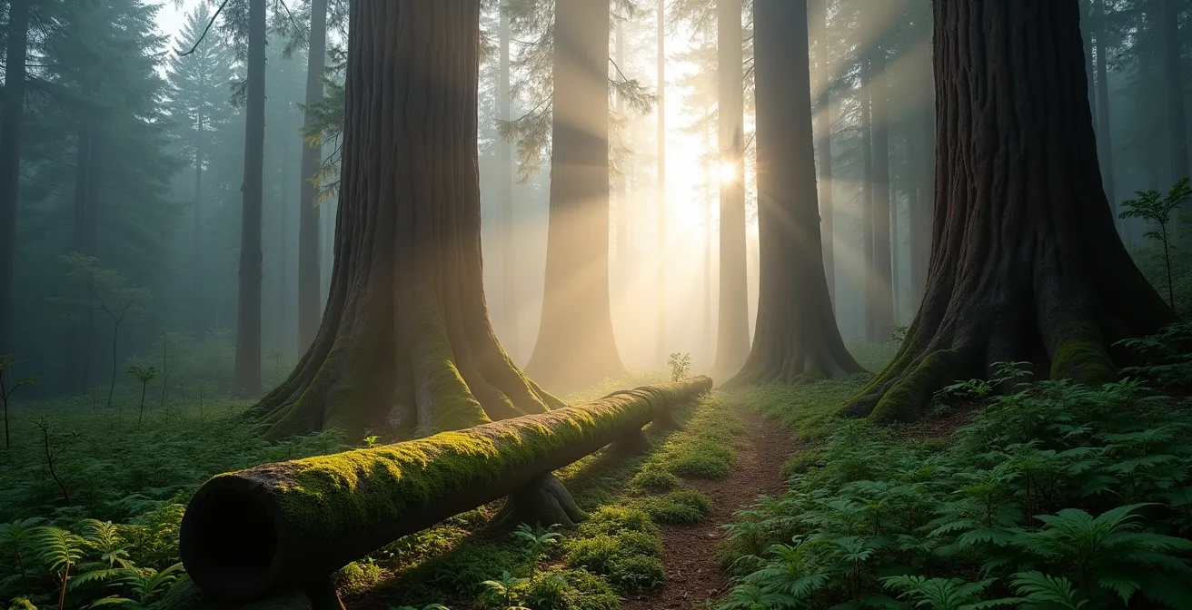
The desire to stand in the presence of a living being that has persisted for eight centuries is a powerful one. On Vancouver Island, giants of Western Red Cedar and Douglas Fir form natural cathedrals that draw visitors from around the globe. For many, the first and only stop is Cathedral Grove, a magnificent but often overwhelmed roadside park. The experience can feel less like a communion with nature and more like navigating a busy parking lot, with the constant hum of traffic and crowds jostling for the same photograph.
The typical advice is to simply find an alternative, like the famed Avatar Grove near Port Renfrew. While a valid starting point, this advice barely scratches the surface. It treats the forest like a commodity, a series of locations to be checked off a list. But what if the real key to a profound experience wasn’t just finding a different pin on a map, but fundamentally changing your approach to visiting? What if the solution wasn’t about avoiding crowds, but about understanding the invisible systems—ecological, logistical, and cultural—that allow these giants to survive?
This guide is built on that premise. It moves beyond a simple “here vs. there” comparison. We’ll explore the science that reveals a tree’s history, the respect required to travel on industrial roads, the hidden life beneath your feet, and the crucial role these forests play in our planet’s health. This is a guide for the nature lover who wants to become a forest guardian, to see the giants not as a backdrop for a selfie, but as venerable elders deserving of informed respect.
For those who prefer a visual introduction, the following video offers a beautiful immersion into the ambiance of Eden Grove, a protected area near Port Renfrew, perfectly complementing the practical advice in this guide.
To help you navigate this deeper journey into the world of ancient trees, this article is structured to build your understanding step by step. From the science of aging these giants to the practicalities of responsible exploration, each section offers a piece of the puzzle to becoming a true forest connoisseur.
Summary: A Guardian’s Guide to Vancouver Island’s Ancient Cedars
- How Do Scientists Date Living Trees Without Cutting Them Down?
- Why Is Land Acknowledgment Important Before Tours in Canada?
- How to Drive on Logging Roads to Reach Avatar Grove Safely?
- Cathedral Grove vs. Ancient Cedars Loop: Which Is More Impressive?
- The “Fatal Selfie” Risk: How Standing on Roots Kills Ancient Trees?
- Carbon Sentinels: Why Are Old-Growth Forests Crucial for BC’s Climate?
- Cedars in Decline: How Is Drought Affecting the “Wet” Rainforest?
- Identifying Invasive Species in BC’s Coastal Forests: What Travelers Should Know
How Do Scientists Date Living Trees Without Cutting Them Down?
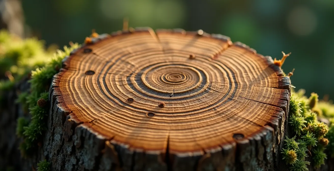
Before we can truly appreciate an 800-year-old cedar, it’s worth asking: how do we know its age? The answer lies in a fascinating science called dendrochronology, the study of tree rings. This method is far more sophisticated than simply felling a tree and counting. Scientists use a tool called an increment borer, a hollow drill bit that extracts a thin, pencil-like core from the trunk without harming the tree’s overall health. This core provides a cross-section of the tree’s life history, a biological archive written in wood.
The precision of this method is remarkable, often allowing dating to the exact calendar year a ring was formed. But these rings tell a story far richer than just age. The width of each ring is a direct reflection of the environmental conditions of that year. A wide ring indicates a good growing season with ample moisture and sunlight, while a narrow ring can signify drought, disease, or intense competition from other trees. It’s a detailed climate diary stretching back centuries.
This detailed record is incredibly valuable. As research into the yellow-cedar on Vancouver Island shows, tree ring analysis reveals complex relationships with the environment. For instance, one study found that 61% of the annual ring width variance could be explained by six different temperature and precipitation variables. By reading these wooden chronicles, scientists can reconstruct past climates, understand long-term growth patterns, and predict how these ancient forests might respond to future environmental stress. Understanding this science is the first step toward appreciating these trees not as static monuments, but as living, dynamic recorders of history.
Why Is Land Acknowledgment Important Before Tours in Canada?
Before setting a single foot on a trail, a responsible visitor in Canada takes a crucial step: acknowledging the land itself. A Land Acknowledgment is a formal statement that recognizes the unique and enduring relationship that exists between Indigenous Peoples and their traditional territories. It’s not just a polite formality or a political platitude; it’s a fundamental act of respect and a crucial part of decolonization. It’s an acknowledgment of a history that predates colonial settlement by millennia and recognizes that these lands are not merely wilderness, but ancestral homes with deep cultural and spiritual significance.
For visitors to Vancouver Island’s ancient forests, this practice is particularly poignant. Many of the most celebrated groves are located on the unceded traditional territories of First Nations. “Unceded” means that the land was never legally surrendered to the Crown or Canadian government through treaty or sale. Ignoring this fact is to ignore the true history of the place you are visiting. Engaging in a land acknowledgment is the first step of the “guardian mindset,” shifting your perspective from that of a consumer of scenery to a respectful guest in someone else’s home.
A Deeper Name: The Case of ‘T’l’oqwxwat’ (Avatar Grove)
The world-famous “Avatar Grove,” which was protected in 2012 after a powerful public campaign, is a modern nickname. Its true name is ‘T’l’oqwxwat’, and it lies within the unceded territory of the Pacheedaht First Nation. The successful campaign to protect the grove, led by the Ancient Forest Alliance, involved a partnership with the Port Renfrew Chamber of Commerce, demonstrating how conservation and community can align. Acknowledging the Pacheedaht name and their stewardship is to honor the deep, multi-generational connection that far outweighs the grove’s recent fame.
Before you visit, take a moment to learn whose territory you will be on. Websites like Native-Land.ca are a valuable resource. Understanding this context enriches your experience, providing a deeper layer of meaning to the ancient trees and the landscape they inhabit. It is the foundation upon which all other acts of responsible tourism are built.
How to Drive on Logging Roads to Reach Avatar Grove Safely?
Reaching the more remote, crowd-free groves of ancient cedars often means leaving the pavement behind. The routes to places like Avatar Grove are typically active industrial logging roads—ungraded, gravel corridors that are the lifeblood of British Columbia’s forest industry. Treating them like a scenic country lane is a dangerous mistake. Safe passage requires what can be called logistical respect: understanding that you are a guest in a hazardous, industrial workplace.
These roads are narrow, often have blind corners, and feature steep, unguarded drop-offs. They are maintained for massive, heavy-laden logging trucks, not for tourist traffic. These trucks have the absolute right-of-way; they cannot stop quickly and have limited maneuverability. Your primary responsibility is to stay out of their way. A vehicle with high clearance is strongly recommended, and all-wheel drive can be essential, especially in wet conditions. Before you even consider the drive, ensure your vehicle is equipped with a full-size spare tire and you know how to change it, as cell service is non-existent.
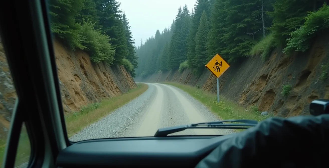
The most critical piece of equipment is a VHF radio tuned to the designated Resource Road (RR) channels. This isn’t just a recommendation; it’s a vital safety protocol. Drivers use the radio to call out their location at marked kilometre points (e.g., “Up on the Harris Main at kilometre 24”). This allows everyone, especially truck drivers, to know who is on the road and where they are. Listening to the chatter gives you advance warning of approaching traffic, allowing you to find a pull-out and wait. Remember, if you meet a logging truck, it is always your responsibility to yield.
Cathedral Grove vs. Ancient Cedars Loop: Which Is More Impressive?
The question of which grove is “more impressive” is common, but it misses the point. The answer depends entirely on what you seek from the experience. Cathedral Grove (MacMillan Provincial Park) and more remote sites like Avatar Grove or the Ancient Cedars Loop Trail near Ucluelet offer two fundamentally different types of encounters with old-growth forests. One is about easy access and immediate grandeur; the other is about adventure and earned solitude.
Cathedral Grove’s primary advantage is its accessibility. Located directly on Highway 4, it requires no special vehicle or extensive planning. Its flat, well-maintained boardwalks make it accessible to people of all ages and mobility levels, including those with wheelchairs. This ease of access, however, is also its biggest challenge. It attracts over a million visitors annually, leading to constant crowds and a less-than-wild atmosphere. It is an impressive but often fleeting roadside stop.
In contrast, destinations like Avatar Grove represent an adventure. Reaching them requires navigating the logging roads we’ve just discussed. The trails are more rugged, often steep and muddy, and maintained by volunteers rather than government bodies. The reward for this effort is a far more intimate and immersive experience. You might have a section of the forest, or even “Canada’s Gnarliest Tree,” all to yourself. It’s a destination, not a pit stop. Choosing this path also supports communities that have embraced ecotourism.
This paragraph introduces the table, explaining its purpose and linking to the source for more detail. As shown by a detailed comparison of the two experiences, the choice is not about which is better, but which aligns with your goals.
| Feature | Cathedral Grove | Avatar Grove |
|---|---|---|
| Accessibility | Paved parking, flat trails, wheelchair accessible | Rough logging roads, steep trails, wilderness area |
| Visitor Numbers | Over 1 million annually | Moderate, especially weekdays |
| Infrastructure | Government-managed boardwalks | Volunteer-maintained trails |
| Experience Type | Quick roadside stop | Adventure destination |
| Notable Features | 800-year-old Douglas firs | Canada’s Gnarliest Tree |
Port Renfrew’s Big Tree Capital Transformation
The story of Port Renfrew exemplifies the positive impact of this choice. Initially a logging town, gaining support for forest conservation was difficult. However, as Jon Cash, the former chamber president noted, the economic benefits of protecting places like Avatar Grove proved real. The town rebranded itself as the “Big Tree Capital of Canada,” distributing maps and welcoming a new wave of nature-loving tourists. By choosing the adventure, visitors directly contribute to a local economy built on preservation rather than extraction.
The “Fatal Selfie” Risk: How Standing on Roots Kills Ancient Trees?
Once you’ve arrived in a quiet grove, the most important aspect of the “guardian mindset” comes into play: forest etiquette. The single most destructive act a visitor can commit, often unknowingly, is stepping off the designated trail. The desire to get closer, to touch the immense trunk, or to frame the “perfect selfie” at the base of a giant leads people to trample the ground around the tree. This seemingly harmless act can be a death sentence for an ancient cedar, delivered slowly over years.
The reason lies in the invisible ecosystem just beneath the surface. The ground around a tree is not inert dirt; it’s a complex, living matrix. A tree’s shallow feeder roots, responsible for absorbing water and nutrients, spread out just below the forest floor. More importantly, these roots are interwoven with a vast network of mycorrhizal fungi. This symbiotic relationship is critical; it is estimated that cedars depend on these fungi for up to 80% of their nutrient uptake. The fungi extend the reach of the tree’s roots, breaking down organic matter and making essential minerals available.
When you step on this ground, your weight compacts the soil. Soil compaction crushes the delicate fungal filaments, strangles the fine feeder roots by cutting off oxygen, and prevents water from penetrating the ground. Repeated foot traffic creates a “dead zone” around the tree’s base, effectively starving it over time. The damage isn’t immediate, but it’s cumulative and irreversible. As the Wild Pacific Trail Society in Ucluelet warns visitors to its own ancient cedar trail:
The forest has many layers of trees growing on fallen logs so solid ground is a maze of cavities that will collapse under foot.
– Wild Pacific Trail Society, Ucluelet’s Wild Pacific Trail
Staying on the boardwalk or designated path isn’t a suggestion; it is the most profound act of respect you can show these ancient beings. Your best photo is one taken from the trail, one that ensures the tree will be there for others to admire for centuries to come.
Carbon Sentinels: Why Are Old-Growth Forests Crucial for BC’s Climate?
The value of ancient forests extends far beyond their beauty and recreational opportunities. These ecosystems are powerful, active players in regulating the global climate, acting as what we can call Carbon Sentinels. For centuries, they have been pulling carbon dioxide from the atmosphere and locking it away in their wood, foliage, and soil. Old-growth forests, particularly the coastal temperate rainforests of British Columbia, are champions of this process, known as carbon sequestration.
The sheer volume of carbon stored is staggering. Research shows that BC’s old coastal forests store up to 1,300 tonnes of carbon per hectare, making them some of the most carbon-dense ecosystems on the planet—more so than tropical or boreal forests. Unlike younger, managed forests where carbon is released through frequent harvesting cycles, old-growth forests act as stable, long-term carbon reservoirs. The carbon captured in an 800-year-old cedar has been kept out of the atmosphere for eight centuries.
However, British Columbia is losing its most effective Carbon Sentinels at an alarming rate. A critical study reveals a concerning disparity: while about a quarter of BC’s total forest area is classified as old, less than 1% consists of the high-productivity old-growth ecosystems that are most effective at storing carbon and supporting biodiversity. On sites that can support these powerhouse forests, only 8% remain as old growth. Protecting these specific, highly productive old-growth stands is not just about preserving big trees; it is a critical climate action, essential for maintaining biodiversity, ecological resilience, and a stable global climate.
Cedars in Decline: How Is Drought Affecting the “Wet” Rainforest?
The term “temperate rainforest” conjures images of perpetual dampness and moss-draped branches, a landscape immune to dryness. However, this image is becoming dangerously outdated. British Columbia’s climate is changing, and even its wettest regions are experiencing longer, hotter, and drier summers. This “drought stress” is placing immense pressure on ancient trees like the Western Red Cedar, a species that evolved in and depends on consistent moisture.
The visible signs of this stress are increasingly apparent to a watchful eye. The most obvious is crown dieback, where the very top of the tree begins to yellow, brown, and lose its foliage. This is a clear signal that the tree is not able to pump enough water to its highest branches. This stress also manifests in reduced growth, which scientists can see in core samples as progressively narrower tree rings, indicating years of struggle. If drought persists, it weakens the tree’s natural defenses, making it vulnerable to secondary threats like root rot fungi and infestations from cedar borer beetles.
The ultimate consequence of prolonged drought is increased fire risk. While a wet rainforest is naturally fire-resistant, a dry one is not. The devastating 2023 wildfire season in British Columbia served as a stark warning. According to a report from Sierra Club BC, a staggering 333,000 hectares of old-growth forests burned in 2023 alone. This represents an estimated 3% of the province’s remaining old growth, wiped out in a single year. This isn’t a distant, future threat; it is a clear and present danger to the very forests we cherish. Understanding this vulnerability adds a layer of urgency and poignancy to any visit.
Key Takeaways
- True responsible tourism goes beyond “Leave No Trace” to an active “guardian mindset” based on understanding the forest’s fragile systems.
- Accessing remote groves requires respecting logging roads as industrial workplaces, prioritizing safety and communication (VHF radio).
- The biggest threat from visitors is soil compaction around tree bases, which destroys the vital root and fungal networks that sustain ancient trees.
Identifying Invasive Species in BC’s Coastal Forests: What Travelers Should Know
The final pillar of the guardian mindset is moving from passive respect to active stewardship. One of the most tangible ways a visitor can contribute positively is by helping to prevent the spread of invasive species. These non-native plants are a significant threat to the health and biodiversity of BC’s coastal forests. They outcompete native plants for light, water, and nutrients, disrupting the delicate ecological balance that has existed for millennia. For a traveler, unknowingly carrying seeds or plant fragments from one area to another can have devastating consequences.
Some of the most problematic invaders in the coastal rainforest environment include English Ivy, which climbs and smothers trees; Scotch Broom, which fixes nitrogen and alters soil chemistry to the detriment of native species; and Himalayan Blackberry, which forms dense, impenetrable thickets. Learning to identify these key species is the first step toward preventing their spread. Once you know what to look for, you can take simple but effective preventative measures.
The “Play, Clean, Go” protocol is an international campaign that provides a simple framework for hikers and travelers. The principle is straightforward: prevent hitchhiking seeds. Before entering a new trail system, and especially after leaving one, thoroughly clean your boots, gear, and even your pets to remove any mud, seeds, or plant material. Staying on designated trails is also crucial, as wandering into the undergrowth is a primary way to pick up and spread seeds. By adopting these habits, you become an active part of the solution, helping to protect the integrity of the native ecosystem for generations to come.
Your Action Plan: The Play, Clean, Go Protocol
- Before entering trail: Remove all visible mud, seeds, and plant material from your boots, clothing, gear, and pets.
- During hike: Stay on designated, durable trails to avoid disturbing the soil and picking up or dropping off invasive seeds.
- After visit: Thoroughly clean all your equipment, including boot treads and bags, before you travel to your next destination.
- Report findings: If you’re confident in your identification, use the ‘Report Invasives BC’ app to photograph and geotag invasive species, helping officials track their spread.
- Learn to identify: Familiarize yourself with the appearance of key local invaders like English Ivy, Scotch Broom, and Himalayan Blackberry.
Adopting this guardian mindset—by understanding the science, acknowledging the history, respecting the logistics, and practicing active stewardship—transforms a simple visit into a meaningful act of conservation. It ensures that the profound silence and ancient presence of these 800-year-old cedars can be experienced not just by you, but by countless generations to come.
Frequently Asked Questions About Visiting Ancient Cedars
What are the visible signs of drought stress in cedars?
The most common signs are crown dieback, which is when the top branches of the tree begin to die and turn brown, premature browning or yellowing of foliage throughout the tree, and a general thinning of the canopy. In scientific analysis, reduced ring width in core samples also confirms periods of stress.
How do tree rings reveal environmental stress?
The thickness of a tree’s annual growth ring is a direct indicator of the conditions it experienced during that year. Wide, healthy rings suggest a good year with sufficient resources. Conversely, a series of very narrow rings indicates a period of struggle, often caused by drought, disease, insect infestation, or intense competition.
Can stressed cedars recover from drought?
Recovery is possible but depends heavily on the duration and severity of the drought, as well as the tree’s overall health. A prolonged drought weakens a cedar’s natural defenses, making it much more susceptible to secondary threats that can ultimately be fatal, such as root rot fungi and damaging insects like cedar borer beetles.