Roads & Horizons
Canada’s vast geography presents road travellers with an unparalleled canvas of experiences. From the rugged coastlines of the Atlantic provinces to the seemingly endless prairies of Saskatchewan, from the geological marvels carved by ancient glaciers to the wildlife-rich corridors of the north, the open road becomes a gateway to understanding this country’s diverse character. Yet the romance of spontaneous adventure must be balanced with practical preparation, route knowledge, and an understanding of the unique challenges that come with traversing the second-largest country on Earth.
The concept of “roads and horizons” captures both the journey and the destination—the километres of asphalt stretching toward distant vistas and the careful planning that transforms a simple drive into a meaningful exploration. Whether you’re considering your first cross-country endurance drive, planning a coastal lighthouse circuit, or navigating the complexities of RV camping regulations, success lies in understanding the fundamentals before you turn the ignition key.
What Makes Canadian Road Trips Unique?
Canadian road travel demands a different mindset than touring more compact regions. The Trans-Canada Highway alone spans nearly 8,000 kilometres from Victoria to St. John’s, representing just one of countless possible routes. This scale creates opportunities unavailable elsewhere: the chance to watch landscapes transform gradually over days of driving, to experience multiple climate zones in a single journey, and to discover communities separated by hundreds of kilometres of wilderness.
Distance fundamentally shapes the Canadian road experience. What appears modest on a map often translates to a full day’s drive. A journey from Thunder Bay to Winnipeg covers over 700 kilometres through the Canadian Shield’s unforgiving beauty, with limited services between communities. This geography rewards those who approach travel with realistic expectations, understanding that remoteness brings both solitude and responsibility. The infrastructure exists—Canada maintains excellent highway systems—but stretches between fuel stations, accommodations, and medical facilities can exceed 200 kilometres in northern regions.
The seasonal dimension adds another layer of complexity. Summer offers extended daylight hours in northern latitudes, with twilight lingering past 11 PM in June, providing extraordinary flexibility for travel. Conversely, winter driving presents serious challenges even on major routes, with potential whiteouts, ice conditions, and the very real possibility of highway closures. Provincial authorities across Canada maintain comprehensive road condition reporting systems, but the onus remains on travellers to monitor forecasts and adjust plans accordingly.
Planning Your Canadian Road Journey
Route Selection and Timing Considerations
Choosing between highway efficiency and scenic alternatives represents one of the first decisions facing road travellers. The Trans-Canada Highway offers the fastest corridor, but provincial highways and secondary routes frequently provide richer experiences. British Columbia’s Sea-to-Sky Highway (Highway 99), the Cabot Trail in Nova Scotia, or the Icefields Parkway in Alberta exemplify routes where the driving itself becomes the primary attraction rather than merely transportation between destinations.
Timing calculations require honest assessment of daily driving capacity. While 800 kilometres might seem achievable in an eight-hour day at highway speeds, this arithmetic ignores rest stops, fuel breaks, construction delays, and the simple fatigue that accumulates over consecutive days of driving. Experienced road travellers typically plan for 400-500 kilometres as a comfortable daily maximum, allowing time for unexpected discoveries and reducing the risk of driver exhaustion.
Technology and Navigation Tools
Modern route planning extends far beyond paper maps, though carrying provincial road atlases remains wise for areas with unreliable cellular coverage. Smartphone applications provide real-time traffic data, construction updates, and alternative routing, but northern and remote areas regularly challenge connectivity. Downloading offline maps before departure eliminates dependency on data networks, while apps specifically designed for RV travel identify height restrictions, weight limits, and propane-filling stations.
Weather monitoring becomes particularly critical for multi-day journeys. Environment Canada’s weather alerts and provincial highway camera systems offer current conditions, but interpreting forecasts requires understanding regional patterns. Prairie thunderstorms develop rapidly on summer afternoons, coastal fog can reduce visibility to near zero within minutes, and mountain passes experience weather completely different from valley conditions just kilometres away.
Vehicle Preparation and RV Considerations
Mechanical Readiness for Distance Travel
Vehicle preparation begins weeks before departure, not the night before. A comprehensive mechanical inspection should verify tire condition (including the spare), brake performance, fluid levels, battery health, and cooling system integrity. The temperature extremes experienced across Canadian regions stress vehicles in ways daily urban driving never reveals. A cooling system adequate for Toronto summer traffic may prove insufficient climbing Rogers Pass in British Columbia with a loaded vehicle.
Emergency equipment transforms from optional to essential in remote areas. Beyond the standard spare tire and jack, consider carrying:
- Jumper cables or a portable battery booster
- Basic tool kit including duct tape and zip ties
- Extra engine oil and coolant appropriate for your vehicle
- Reflective warning triangles or flares
- First aid kit with supplies for multiple days
- Emergency food, water, and warm clothing regardless of season
Choosing and Operating an RV
The recreational vehicle market offers configurations from compact camper vans to 40-foot motorhomes, each presenting different advantages and limitations. First-time RV travellers often underestimate the learning curve associated with operating these vehicles. A Class A motorhome handles nothing like a sedan, requiring practice with wider turns, extended braking distances, and constant awareness of height clearances. Many rental companies provide orientation sessions, but genuine comfort comes only through experience.
Understanding campground infrastructure helps match vehicle choice to travel plans. Full-service campgrounds provide electrical hookups (typically 30 or 50 amp), water connections, and sewer disposal, enabling extended stays with full amenities. In contrast, wild camping—the practice of overnight parking outside designated campgrounds—exists in a legal grey area across Canada. While generally tolerated on Crown land in many provinces, restrictions vary significantly by jurisdiction, and certain areas strictly prohibit the practice. Provincial and territorial regulations require research specific to your route.
Budget Realities and Cost Management
The financial aspect of RV travel frequently surprises newcomers. Beyond the rental or purchase cost, campground fees range from $25-75 per night depending on location and amenities, with popular destinations near national parks commanding premium rates. Fuel consumption for larger motorhomes typically falls between 25-35 litres per 100 kilometres, making fuel a substantial expense on long journeys. Add propane for cooking and heating, occasional generator use, dump station fees where applicable, and the total daily cost can easily exceed $200 during peak season.
Booking strategy significantly impacts both availability and cost. Popular campgrounds in national parks like Banff or Jasper fill months in advance during summer, requiring reservations through Parks Canada’s system the moment booking windows open. Provincial parks operate separate reservation systems, while private campgrounds may offer more flexibility but at higher prices. Last-minute spontaneity works best outside peak season or in less-visited regions.
Coastal Routes and Maritime Heritage
Canada’s 243,000 kilometres of coastline—the longest of any nation—provides extraordinary opportunities for road travellers drawn to maritime environments. Coastal routes offer a fundamentally different character than inland highways: the constant presence of the ocean, the engineering required to carve roads along cliff faces, and the cultural heritage of communities shaped by their relationship with the sea.
Lighthouse Circuits and Navigation History
Lighthouses represent tangible connections to Canada’s maritime past, and many remain accessible by road. The engineering evolution visible across these structures tells the story of navigation technology: from simple stone towers with oil lamps to automated facilities with solar panels and satellite communication. British Columbia’s coastal Highway 14 passes multiple historic lighthouses, while the Cabot Trail in Nova Scotia provides access to sites documenting Atlantic fishing heritage.
Planning a lighthouse-focused route requires understanding access limitations. Many historic lights now serve as museums or bed-and-breakfast establishments, offering tours during limited hours. Others remain active aids to navigation with restricted public access. Photography enthusiasts should note that optimal lighting conditions—typically the golden hours around sunrise and sunset—may conflict with visiting hours, requiring overnight stays in nearby communities to capture desired images.
Coastal Safety Awareness
The beauty of coastal environments coexists with genuine hazards. Wave dynamics along exposed shorelines create dangerous conditions with little warning. Sneaker waves—larger-than-average waves that arrive unexpectedly—have caused fatalities along both Pacific and Atlantic coasts. Rocky outcrops that appear safe during calm conditions become treacherous when swells increase or tides change. Observation requires maintaining distance from the waterline, staying alert to changing conditions, and respecting warning signs even when conditions appear benign.
Fog presents another coastal challenge, reducing visibility to a few metres with remarkable speed. Drivers accustomed to inland conditions often underestimate how quickly fog transforms familiar roads into navigation challenges. Reducing speed, using low-beam headlights (high beams reflect off fog, worsening visibility), and increasing following distance become essential adjustments.
Prairie Landscapes and Open Horizons
The prairie provinces—Manitoba, Saskatchewan, and Alberta—challenge common assumptions about scenic driving. Where mountain or coastal routes offer constant visual stimulation through curves and elevation changes, prairie highways present a different aesthetic: one of space, sky, and subtle variations that reward patient observation. The experience initially strikes some travellers as monotonous, yet this perception often shifts as one attunes to the landscape’s particular beauty.
Understanding Prairie Aesthetics
The dramatic skies that characterize prairie regions result from specific atmospheric conditions. The absence of topographic barriers allows weather systems to develop fully visible character, creating cloud formations and light effects rarely seen in mountainous terrain. Summer thunderstorms build as towering cumulonimbus structures, their development tracked across 50 kilometres of visibility. Sunrise and sunset paint the entire dome of sky rather than being confined to narrow valley views.
Timing drives significantly impact the agricultural visual experience. Spring planting creates patterns of brown earth punctuated by emerging green. Mid-summer presents fields of canola in brilliant yellow, wheat in green transitioning to gold, and the geometric patterns of modern farming practices visible for kilometres. Autumn harvest brings combines working through golden fields, with straw bales dotting the landscape. Each season offers distinct colours and activities.
Finding Visual Interest and Managing Fatigue
The straight highways and consistent speeds of prairie driving create fatigue risks different from mountain passes or winding coastal roads. The lack of curves reduces the active engagement required for navigation, potentially leading to highway hypnosis—a trance-like state where drivers continue operating their vehicle with reduced awareness. Combating this requires deliberate strategies: frequent stops to break the rhythm, switching drivers regularly, and avoiding marathon driving sessions that push beyond safe alertness levels.
Seeking elevation provides perspective on prairie landscapes. While these regions lack dramatic mountains, river valleys, escarpments, and even modest hills offer viewpoints that reveal the land’s subtle contours. The Manitoba Escarpment, Cypress Hills in Saskatchewan, or river valleys throughout the region provide these elevated perspectives, transforming the “flat” prairie into a landscape of gentle rolls and surprising depth.
Geological Wonders Along Canadian Highways
Canada’s geological diversity—the product of plate tectonics, glaciation, volcanic activity, and millions of years of erosion—creates natural laboratories accessible from major highways. The Canadian Shield’s ancient Precambrian rock exposed in Ontario, the sedimentary layers of Alberta’s Badlands, the volcanic formations of British Columbia’s interior, and the limestone caves of the Rockies each tell different chapters of Earth’s history.
Erosion Mechanics and Landscape Formation
Understanding the processes that created visible formations enhances appreciation beyond mere sightseeing. The hoodoos of Alberta’s Drumheller region formed through differential erosion: harder caprock protecting softer sedimentary layers beneath, creating mushroom-shaped pillars. Glacial action carved the U-shaped valleys visible throughout the Rockies, while post-glacial rebound continues reshaping the land around Hudson Bay at measurable rates even today.
The concept of geological time—processes occurring over millions of years—becomes tangible at sites like the Burgess Shale in British Columbia, where 508-million-year-old fossils preserve soft-bodied organisms in remarkable detail. Similarly, the layered sediments visible along the Icefields Parkway represent sequential deposition spanning vast time periods, each layer a snapshot of ancient environmental conditions.
Safe Observation and Flash Flood Awareness
Accessing geological sites requires awareness of natural hazards. Canyon environments and badland formations, while visually spectacular, concentrate water flow during precipitation events. Flash floods can transform dry washes into raging torrents within minutes, with water arriving before rain falls at your location due to upstream weather. Identifying safe observation zones means checking weather forecasts for the entire watershed, avoiding narrow canyon bottoms when precipitation threatens, and recognizing warning signs like sudden temperature drops or distant thunder.
Many significant geological sites fall within provincial or national parks, where interpretive programs and guided hikes provide educational value beyond self-directed observation. Parks Canada and provincial equivalents employ interpreters who explain formation processes, point out details easily missed by untrained observers, and ensure visitors appreciate sites without contributing to erosion or damage.
Wildlife Safety on Northern Roads
Wildlife-vehicle collisions represent a significant safety concern across Canadian highways, particularly in regions where development intersects animal habitat. Transport Canada statistics indicate tens of thousands of wildlife collisions occur annually, ranging from minor encounters with small animals to catastrophic impacts with moose or elk. The northern latitudes, longer dusk periods, and extensive wilderness areas traversed by major highways create conditions where wildlife encounters become routine rather than exceptional.
Understanding Collision Physics and Risk Factors
The physics of wildlife collisions vary dramatically with animal size. A collision with a 600-kilogram moose at highway speed transfers enormous energy, often with the animal’s mass striking at windshield height due to their long legs. The results frequently prove catastrophic for both vehicle occupants and animal. Deer, while smaller, still create serious hazards, particularly when multiple animals cross simultaneously or when swerving reactions cause loss of control.
Seasonal patterns influence collision risk. Spring brings animals to roadways seeking salt deposited during winter road maintenance and tender vegetation in road clearings. Autumn mating seasons increase animal movement and reduce their caution. Dawn and dusk represent peak activity periods for many species, coinciding with reduced visibility that compromises driver reaction time.
Prevention Strategies and Evasive Techniques
Effective headlights extend reaction time by improving long-range visibility, but standard headlights remain limited in northern environments. Some drivers install auxiliary lighting, though regulations vary by province regarding additional lamp use. The common advice to “use high beams when safe” takes on greater importance in wildlife country, as the increased illumination range provides precious additional seconds to identify animals near the roadway.
Executing evasive maneuvers requires split-second decisions with serious consequences. The traditional advice—brake firmly but maintain your lane rather than swerving—reflects the reality that leaving the roadway or crossing into oncoming traffic often causes worse outcomes than the initial collision. However, this guidance assumes unavoidable impact. When time and space allow, controlled braking while maintaining lane position provides the safest response. Swerving should occur only when the alternative guarantees a worse outcome and clear escape space exists.
Warning signs indicating wildlife crossing zones deserve serious attention, yet relying solely on signage creates false security. These markers identify areas of documented collision history or known migration routes, but animals cross highways everywhere. Constant vigilance matters more than sign locations, particularly during high-risk periods. Scanning roadsides systematically, reducing speed in areas with limited sight lines, and maintaining awareness of animal behaviour patterns all contribute to safer travel through wildlife territory.
The diversity of Canada’s roads and horizons—from maritime heritage routes to prairie highways, from geological wonders to wildlife corridors—creates opportunities for discovery that few other nations can match. Yet this same diversity demands preparation, respect for distances and conditions, and realistic planning that balances ambition with safety. The open road beckons, but successful journeys result from understanding what lies beyond the horizon before you reach it.

Night Driving in Northern Ontario: How to Spot a Moose Before It’s Too Late?
In summary: Moose are taller than your headlights, so look for dark shapes and silhouettes, not just eye-shine. The extreme danger comes from the moose’s height and weight, causing it to crash through the windshield, not onto the hood. In…
Read more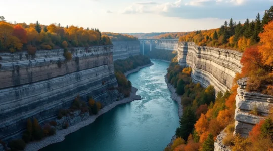
Driving the Niagara Parkway: A Geologist’s Guide to River-Carved Landscapes
The Niagara landscape is not a static monument; it’s a dynamic geological laboratory actively being carved and shaped by powerful forces you can witness firsthand. The famous Horseshoe Falls recedes due to “differential erosion”—the undercutting of soft shale beneath a…
Read more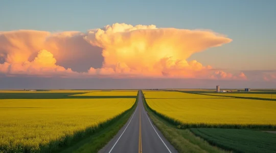
Driving Across Saskatchewan: Why the “Living Skies” Are Best Seen in July?
Most travellers believe the prairie drive is a monotonous void to be endured. The truth is, it’s a dynamic canvas that requires a new way of seeing. This guide reveals that by understanding the unique physics of prairie light, the…
Read more
Renting an RV in Alberta: What Size Vehicle Fits National Park Campsites?
The best RV for the Canadian Rockies isn’t the biggest or most luxurious, but the most agile one that grants you full access. Your vehicle’s size directly dictates your ability to access key roads, viewpoints, and trailheads in Banff and…
Read more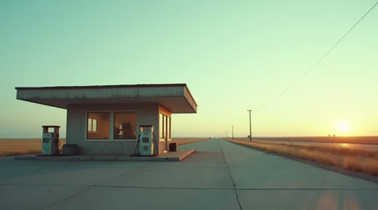
The Real Rules of the Road: Fueling Your Way Across the Trans-Canada’s Empty Quarters
Success on a cross-Canada drive isn’t about the gas stations on your map; it’s a mental game against landscape deception and your own complacency. Digital tools are unreliable in remote areas; real-world intel and a healthy dose of skepticism are…
Read more
Beyond the Postcard: Which 5 Historic Lighthouses in Nova Scotia Are Worth the Detour?
In summary: A successful lighthouse road trip in Nova Scotia requires strategic planning that goes beyond just visiting the most famous spots. Understanding the history, like the revolutionary Fresnel lens, adds depth to your journey and appreciation for each location….
Read more