The Niagara landscape is not a static monument; it’s a dynamic geological laboratory actively being carved and shaped by powerful forces you can witness firsthand.
- The famous Horseshoe Falls recedes due to “differential erosion”—the undercutting of soft shale beneath a hard dolostone caprock.
- The Niagara Escarpment’s shape creates a unique microclimate, trapping warm air that allows for the cultivation of tender fruits and grapes.
Recommendation: Use this guide to transform your drive from simple sightseeing into a field expedition, learning to read the clues left by water, rock, and time.
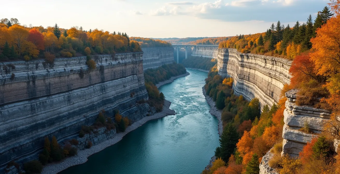
For most visitors, the Niagara Parkway is a ribbon of asphalt connecting breathtaking viewpoints. You drive, you stop, you marvel at the sheer power of the falls and the dramatic depth of the gorge. But to a geomorphologist, this landscape is a living narrative, a story written in stone and water over 12,500 years—a story that is still unfolding. The common approach is to appreciate the view; our approach is to understand the engine that creates it.
Many guides will tell you the basic facts: the age of the falls, the names of the wineries. They treat the landscape as a finished product. This guide does the opposite. We will treat it as an active process. The key to truly appreciating the Niagara Gorge is not just to see it, but to learn how to read it. Why does the water have that distinct green colour? What do the cracks in the rock walls tell you about their stability? Why can you grow peaches here and not 50 kilometres north?
This journey along the parkway will reframe your perspective. We’ll move beyond simple observation and delve into the geomorphic forces at play. You will learn to identify the evidence of constant change, to understand the relationship between ancient bedrock and modern agriculture, and to see the river not just as water, but as the primary sculptor of this entire region. This isn’t just a scenic drive; it’s a lesson in how our planet works, visible right outside your car window.
This article will guide you through the key geological questions that unlock the story of the Niagara region. We will examine the forces shaping the falls, the composition of the gorge walls, and the subtle environmental factors that make this area so unique.
Summary: A Geologist’s Interpretation of the Niagara Parkway
- Why Does the Horseshoe Falls Recede by 30cm Every Year?
- How to Spot Unstable Overhangs While Walking the Gorge Trail?
- The Water Release Warning: Why Does the River Level Rise Suddenly?
- Silurian vs. Ordovician: Which Rock Layers Are Visible at the Whirlpool?
- Interpretive Plaques vs. Guidebook: Which Explains the Gorge Better?
- Why Is Limestone Often Polished and Slippery on Popular Routes?
- Why Is the Niagara Peninsula Able to Grow Peaches and Grapes?
- Sport Climbing at Niagara Glen: Do You Need a Permit to Boulder?
Why Does the Horseshoe Falls Recede by 30cm Every Year?
The constant, thunderous retreat of Niagara Falls is the region’s most dramatic geological process, but it’s not driven by sheer force alone. The mechanism is a classic case of differential erosion. The entire Niagara Escarpment is like a layer cake of rock, with a hard, resistant caprock made of Lockport Dolostone sitting atop softer, easily eroded layers of Rochester Shale. The immense power of the river scours the base of the falls, rapidly washing away the soft shale. This undercutting leaves the durable dolostone caprock hanging unsupported, like a shelf with its brackets removed. Eventually, gravity wins, and massive blocks of the caprock collapse into the river below, causing the falls’ crest to “recede” upstream.
This process is relentless, though its pace has been significantly altered by human intervention. Before the 20th century, the falls retreated at a rate of over a meter per year. Today, that rate has been slowed. According to official data from Niagara Parks, the Horseshoe Falls currently recedes at a rate of about 1 foot per year (30cm). This slowdown is a direct result of the 1950 Niagara Treaty, which allows for massive amounts of water to be diverted from the river to hydroelectric power plants on both the Canadian and American sides. By reducing the volume of water flowing over the crest, especially at night, we have effectively put the brakes on erosion.
You can see evidence of this erosive power everywhere. The vibrant green colour of the Niagara River isn’t from pollution; it’s a tribute to its erosive force. An estimated 60 tons of dissolved minerals and rock flour are swept over the falls every minute, creating the distinct hue. As you stand at a viewpoint, observe the massive talus slopes (piles of fallen rock) at the base of the falls—these are the direct result of the caprock collapse that drives the recession.
How to Spot Unstable Overhangs While Walking the Gorge Trail?
Walking the trails of the Niagara Gorge brings you face-to-face with the same geological forces that shape the falls, but on a more intimate scale. The gorge walls are not static; they are in a constant state of slow-motion collapse. Understanding how to spot signs of instability is crucial for safety and provides a deeper appreciation for the active geology around you. The same principle of a hard caprock over soft shale is at play, and water is the key agent of failure.
Groundwater constantly seeps through the porous limestone and dolostone layers. When it reaches an impermeable shale layer, it moves horizontally, lubricating the boundary between rock strata. In winter, this water freezes and expands—a process called frost wedging—prying the rock apart from the inside. This is why you must always be vigilant for signs of active erosion.
As you hike, train your eyes to look for these specific geological clues of instability:
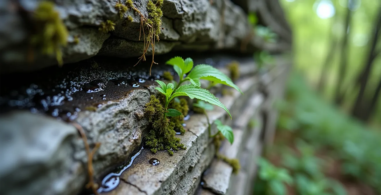
The image above perfectly illustrates one of the most important warning signs. Look for dark, wet patches or “weeping” rock faces, which indicate groundwater seepage lubricating potential failure planes. Also, pay attention to the following:
- Listen: The sound of small, falling pebbles (scree) is a direct indicator of an active erosion zone above you.
- Look for Scars: Freshly exposed rock surfaces will be lighter in colour than the surrounding weathered rock. These “scars” mark the location of recent rockfalls.
- Observe Vegetation: Trees or large shrubs growing directly from rock faces can act as levers. Their roots penetrate cracks, and as they grow and sway in the wind, they widen these fissures.
- Identify Cracks: Look for visible cracks, especially horizontal ones that run parallel to the rock layers, that appear to be widening. These are points of future separation.
The Water Release Warning: Why Does the River Level Rise Suddenly?
Hikers and boulderers near the river’s edge in the Niagara Gorge are often surprised by the sudden and significant rise in water level. This is not a random natural event; it is a highly controlled and predictable process directly tied to hydroelectric power generation. The Niagara River is managed as a massive utility, with its flow carefully manipulated to balance two competing demands: tourism and energy production.
During the peak tourist season (roughly May to October), the 1950 Niagara Treaty mandates that a minimum flow must be maintained over the falls during daylight hours for scenic purposes. This flow is set at 100,000 cubic feet per second. However, once the sun sets and the crowds depart, the priority shifts to power generation. The flow over the falls is drastically reduced to just 50,000 cubic feet per second. The “missing” water isn’t gone; it’s being diverted through massive underground tunnels to the Sir Adam Beck generating stations on the Canadian side and the Robert Moses plant on the U.S. side.
This nightly diversion means that after sunset, the water level in the reservoirs above the plants drops, and consequently, the water level in the gorge below the falls rises as the power turbines release their flow. This change can be swift and can easily trap anyone who is too close to the water’s edge. From November to April, the tourist-focused flow requirements are relaxed, and an additional 50,000 cubic feet per second can be diverted for power, making the flow even more variable. This is why warning signs are posted throughout the gorge and why it is critical for anyone venturing near the river to be aware of the time of day and the seasonal schedules.
Silurian vs. Ordovician: Which Rock Layers Are Visible at the Whirlpool?
The Niagara Whirlpool is one of the best locations in the entire gorge to see the region’s geological layer cake exposed in dramatic fashion. Here, the river has carved down through hundreds of millions of years of Earth’s history, revealing distinct rock strata from two different geological periods: the younger Silurian Period on top and the more ancient Ordovician Period at the bottom. As a geomorphologist, this is like reading chapters in a book. Each layer tells a story of a different ancient environment.
The most prominent and important layer is the Lockport Dolostone, the hard, grey Silurian-age caprock that forms the cliffs’ upper edge. This is the same resistant layer that forms the crest of Niagara Falls. Below it lie softer Silurian shales and sandstones. But the most visually striking transition occurs near the river level. Here, the grey colours of the Silurian rocks give way to the distinctive reddish-purple mudstones of the Ordovician-age Queenston Shale. This colour comes from iron oxides that were present in the ancient muddy delta environment where this rock was formed around 445 million years ago.
The following table breaks down the main layers you can identify while looking down into the gorge at the Whirlpool.
| Rock Layer | Geological Period | Age (Million Years) | Characteristics | Location in Gorge |
|---|---|---|---|---|
| Lockport Dolostone | Silurian | 430 | Hard, blocky, grey, fossil-rich | Cliff tops/caprock |
| Rochester Shale | Silurian | 435 | Soft, easily eroded, dark grey | Middle layers |
| Thorold Sandstone | Silurian | 440 | Grey, medium hardness | Transition zone |
| Queenston Shale | Ordovician | 445 | Distinctive reddish-purple, mudstone | River level/base |
For the avid fossil hunter, the talus slopes at the base of the cliffs are treasure troves. As the rock walls erode, they release a bounty of Silurian marine fossils. You can find shell-shaped brachiopods, circular crinoid stems that look like stacked coins, and the delicate patterns of ancient corals, all preserved within the grey limestone and dolostone blocks that have tumbled down to the river’s edge. This information, based on comprehensive geological surveys, is well-documented by sources like publications from academic and encyclopedic resources.
Interpretive Plaques vs. Guidebook: Which Explains the Gorge Better?
Along the Niagara Parkway, you’ll find numerous interpretive plaques. While well-intentioned, these static displays often provide a simplified, and sometimes outdated, view of the region’s complex geology and history. For the curious road-tripper, they are a starting point, but they are far from the best way to understand the gorge. A modern, multi-source approach, much like using a dynamic guidebook, offers a far richer and more accurate education.
The primary limitation of plaques is their static nature. Geological understanding evolves, but the metal signs do not. Furthermore, they lack the depth to explain the processes behind the facts they present. A plaque might state the age of a rock layer, but it can’t show you a 3D model of the ancient sea where it formed. Today, a wealth of superior digital resources allows you to carry an entire geological library in your pocket.
To truly understand the landscape, consider augmenting or replacing the information on plaques with these more powerful tools:
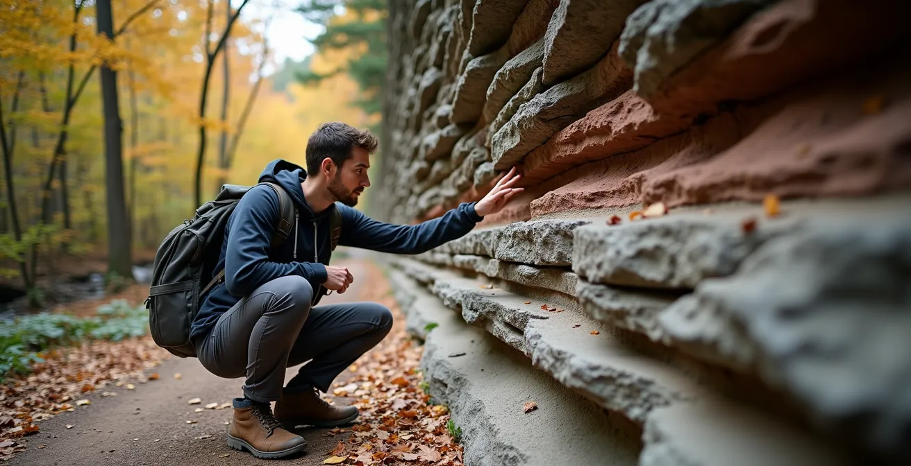
Instead of passively reading a plaque, you can actively engage with the geology, much like the hiker in the photo. Your smartphone can become your expert guide. For a truly deep dive, consider these digital-first options:
- University Resources: Access virtual field trips, like those from Brock University’s Earth Sciences department, which provide expert-level detail and context far beyond any plaque.
- Mobile Apps: Download apps from organizations like the Geological Survey of Canada that can use your phone’s GPS to provide location-specific information as you travel.
- Cultural Centers: Visit local Indigenous cultural centers, whose oral traditions and stories offer a completely different and deeply valuable perspective on the land’s formation and significance.
- Online Learning Hubs: Use free online resources like the Niagara Geopark’s Learning Hub to take short courses on the specific geological features you are about to visit.
Why Is Limestone Often Polished and Slippery on Popular Routes?
As you walk along high-traffic paths like the White Water Walk or the main trails in the Niagara Glen, you’ll notice that the limestone underfoot is often smooth, dark, and surprisingly slippery, especially when wet. This isn’t the natural state of the rock; it’s a phenomenon known as limestone polish, created by a combination of mechanical and chemical forces.
First is the mechanical process: abrasion. The millions of footsteps that pass over these surfaces each year act like a fine-grit sandpaper. Each shoe grinds away microscopic irregularities in the rock, slowly smoothing its surface. Dust and grit trapped under shoes accelerate this process, buffing the rock to a mirror-like finish over decades. You can see a clear contrast by comparing the polished rock on the main path to the rough, pitted texture of untouched limestone just a few metres away.
Second is the chemical process: dissolution. The limestone and dolostone of the gorge are carbonate rocks, which are susceptible to being dissolved by acid. Southern Ontario’s rain is naturally slightly acidic, forming weak carbonic acid. This acid reacts with the calcite in the limestone, slowly dissolving the surface layer. The combination of this chemical softening with the constant mechanical abrasion from foot traffic creates the perfect conditions for a slick, polished surface to develop. When wet, a thin film of water acts as a lubricant, drastically reducing friction and making these polished areas dangerously slippery.
To navigate these surfaces safely, always wear footwear with good rubber traction. Before committing your full weight, test the grip of a suspicious-looking patch. Interestingly, you can sometimes look for the “fossil ghost effect”—the faint outlines of fossils that are made of a slightly harder material (like silica) and may protrude a fraction of a millimeter, offering a slightly better grip.
Why Is the Niagara Peninsula Able to Grow Peaches and Grapes?
The Niagara Peninsula’s reputation as Canada’s premier fruit and wine region is not an accident of agriculture; it’s a direct consequence of its unique geology. The same Niagara Escarpment that creates the famous falls also functions as a massive, natural climate-control machine, creating a series of microclimates perfect for growing tender fruits like peaches, as well as cool-climate wine grapes like Riesling, Chardonnay, and Pinot Noir.
The escarpment, which runs east-west through the peninsula, acts as a physical barrier. In the spring, it protects the budding vines and trees on the plains below from cold south-westerly winds. Throughout the growing season, the nearby waters of Lake Ontario absorb the sun’s warmth. Prevailing winds blow this warmer air inland, where it is trapped against the north-facing slope of the escarpment. This creates a pocket of moderated, warmer air that extends the growing season and prevents devastating late-spring or early-autumn frosts. This “lake effect” is the single most important factor in the region’s agricultural success.
This has allowed the Niagara Peninsula to become the largest wine-producing appellation in Canada. The benchlands—the terraces along the escarpment’s slope, such as the Beamsville Bench and Twenty Mile Bench—are particularly prized for viticulture. Data shows that this geologically-defined region is home to a vast agricultural zone, with 13,600 hectares (over 33,000 acres) dedicated to wine production alone within the VQA Niagara Peninsula appellation. So when you enjoy a glass of local wine, you are tasting the direct result of the escarpment’s geomorphic influence on the local climate.
Key Takeaways
- The Landscape is Active: The Niagara Gorge is not a static feature but is constantly being shaped by differential erosion, frost wedging, and human-managed water flow.
- Geology Creates Economy: The shape and position of the Niagara Escarpment create a unique microclimate that is the foundation of the region’s world-renowned wine and fruit industry.
- Safety Through Knowledge: Understanding the geological processes, from unstable overhangs to scheduled water releases and polished rock surfaces, is essential for safely exploring the gorge trails.
Sport Climbing at Niagara Glen: Do You Need a Permit to Boulder?
Yes, a permit is absolutely mandatory for anyone who wishes to go bouldering in the Niagara Glen. This is not a suggestion; it’s a strict requirement enforced by Niagara Parks to manage the unique and sensitive climbing environment. The Glen is a world-class bouldering destination, and the permit system is a critical tool for conservation, safety, and maintenance of this valuable natural resource.
The rock itself is what makes the Glen so special for climbers. Unlike typical limestone, the Lockport Dolostone here is “solution-strengthened.” Over millennia, water has dissolved softer parts of the rock, leaving behind a harder, blockier structure with excellent friction and an abundance of positive holds like crimps, jugs, and pockets. With over 600 documented boulder problems, the area is a major hub for the sport. The Ontario Alliance of Climbers (OAC) works closely with Niagara Parks to ensure access is maintained sustainably. As stated by Garrett Hutson of the OAC, “The Glen is a unique climbing resource and the OAC continues to support the use of bouldering permits”.
The funds generated from these permits are reinvested directly into the area, supporting trail maintenance, environmental protection initiatives, and the management of climbing access. Seasonal closures are also implemented to protect the ecosystem, ensuring the quality of both the environment and the climbing experience is preserved for years to come. Getting a permit is a straightforward process and a vital part of being a responsible climber in the Glen.
Your Action Plan: Securing a Niagara Glen Bouldering Permit
- Confirm Requirement: Understand that bouldering permits are required for all participants. Accessing the area for climbing without one can result in fines.
- Purchase Permit: You can purchase your permit online in advance at the official niagaraparks.com website or in person at the Niagara Glen Nature Centre upon arrival.
- Choose Duration & Cost: Decide between an Annual Permit (around $45 CAD, which includes a parking pass for two vehicles) or a Daily Permit (around $23 CAD for single-day access).
- Complete Waiver: You must fill out and sign the liability waiver form, which is available both online during the purchase process and on-site.
- Carry Proof: Always carry your permit with you while in the bouldering area. Niagara Parks staff conduct regular checks to ensure compliance.
Now that you can read the story written in the rocks, your next drive along the Niagara Parkway will be a completely different experience. Go out and apply this knowledge, transforming your journey into a true geological field expedition.