Most travellers believe the prairie drive is a monotonous void to be endured. The truth is, it’s a dynamic canvas that requires a new way of seeing. This guide reveals that by understanding the unique physics of prairie light, the subtle language of the horizon, and the sensory rhythm of the land, the drive transforms from a test of patience into an immersive artistic experience, especially during the peak colours and dramatic skies of July.
The long-haul drive across Saskatchewan carries a certain reputation. For many, it’s the geographic hurdle between the Rockies and the East, a seemingly endless stretch of flat land to be crossed as quickly as possible. The common advice is to load up on podcasts, arm yourself with coffee, and simply push through. The focus is always on distraction, on finding something—anything—to look at other than the road itself. Roadside attractions and quaint small towns become welcome, but brief, interruptions in the perceived monotony.
But what if this entire approach is wrong? What if the key isn’t to look away from the landscape, but to look deeper into it? The prairie is not an empty space; it is an exercise in minimalism and atmospheric grandeur. From a landscape artist’s perspective, this province isn’t defined by what it lacks, but by what it possesses in abundance: sky, light, and a horizon so vast it bends the rules of perception. The supposed ’emptiness’ is actually a canvas, and in July, it is at its most vibrant and expressive.
This guide abandons the conventional wisdom of simply ‘surviving’ the drive. Instead, it offers a new framework for experiencing it. We will explore the science behind the spectacular prairie light, learn how to read its subtle topography for photographic advantage, and engage our senses to combat the lull of the straight road. We will see the drive not as a distance to be covered, but as a gallery to be appreciated, one where the main exhibit is the living sky itself.
To fully appreciate this journey, this article breaks down the essential elements that transform a simple drive into a profound encounter with the Canadian prairies. The following sections will guide you through the science, history, and sensory details that unlock the soul of Saskatchewan’s landscape.
Summary: An Artist’s Guide to the Saskatchewan Prairie Drive
- Why Are Sunsets in the Prairies More Vivid Than in the Mountains?
- How to Find High Ground in a Flat Province for Photography?
- Canola Fields in Bloom: When Is the Best Week to See a Yellow Sea?
- Red Coat Trail vs. Trans-Canada: Which Drive Offers Better History?
- Combating Monotony: How to Stay Alert on Straight Roads for 8 Hours?
- Why Is “Highway Hypnosis” Dangerous on the Prairie’s Straight Roads?
- Why Is the “Blue Hour” Longer in Northern Canada Than in the Tropics?
- Farm Stays in Manitoba: How to Disconnect Digitally for a Weekend?
Why Are Sunsets in the Prairies More Vivid Than in the Mountains?
The legendary “Living Skies” of Saskatchewan are not a myth; they are a direct result of atmospheric optics unique to this landscape. Unlike mountainous regions where peaks obstruct the horizon, the prairies offer an unbroken 180-degree view. This allows you to witness the entire spectacle of a sunset, from the first golden glow to the last violet wisps. The magic, however, lies in the composition of the air itself. The vast agricultural landscape means the lower atmosphere is often filled with a fine suspension of natural aerosols—dust, pollen, and moisture—kicked up from the fields. These particles act as a natural diffuser, scattering the blue light away from our line of sight and allowing the warmer reds, oranges, and pinks to dominate the sky for an extended period.
Furthermore, the sun’s trajectory is key. As it sinks towards the flat horizon, its light travels through a much thicker slice of the Earth’s atmosphere than it would at midday. This long journey filters out even more of the cooler colours, intensifying the warm palette. This phenomenon creates the famous golden hour glow that can seem to last for an eternity on a Saskatchewan summer evening. The result is a richer, more saturated, and longer-lasting colour show than in areas where the sun abruptly disappears behind a mountain. It’s not just a sunset; it’s a slow, immersive performance of light and particle physics on a continental scale.
For photographers, this means the window of opportunity is remarkably generous. The photographic ‘blue hour’—that period of twilight after sunset when the sky is filled with a deep, serene blue—is also prolonged. In fact, a travel guide notes that the photographic blue hour in Saskatchewan during July lasts 45-50 minutes, giving artists ample time to capture the shifting moods of the prairie canvas. The key is to be patient and watch as the colours evolve long after the sun has vanished.
How to Find High Ground in a Flat Province for Photography?
The question of finding elevation in a province renowned for its flatness is a classic challenge for landscape photographers. While Saskatchewan lacks mountains, it is not a perfectly level table. The key is to train your eye for “subtle topography.” This includes seeking out the gentle rises of ancient glacial moraines, the shallow valleys carved by rivers like the Qu’Appelle, and the dramatic badlands of the Frenchman River Valley. The province’s highest natural point is found within Cypress Hills Interprovincial Park, an astonishing anomaly rising high above the surrounding plains. This park offers rolling hills and forested plateaus, providing photographers with dramatic vantage points and a stark contrast to the expected prairie scenery.
However, the most iconic and accessible form of “high ground” is man-made: the historic wooden grain elevator. These “prairie sentinels” were once the tallest structures for hundreds of kilometres in every direction. While many are gone, the ones that remain are powerful compositional elements. They are not just subjects; they are platforms. They provide a vertical counterpoint to the overwhelming horizontal composition of the landscape, breaking the horizon and drawing the eye upward. Finding one of these weathered giants against a dramatic sky is the quintessential Saskatchewan photograph.
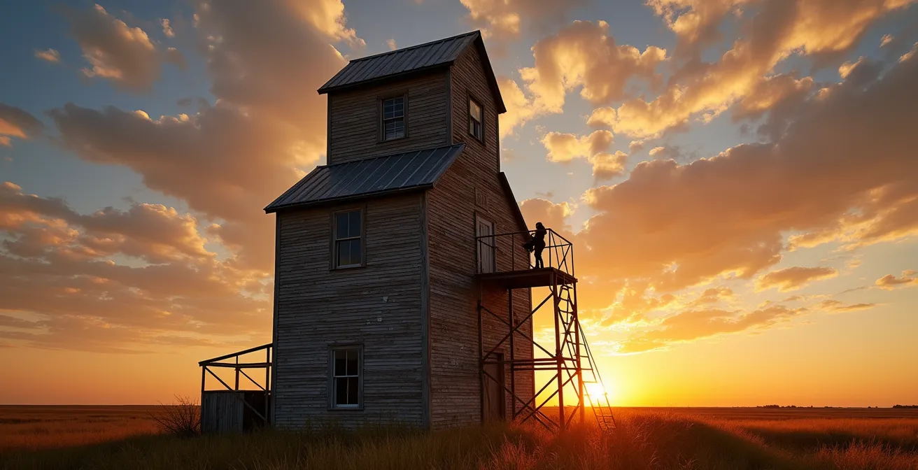
As the illustration above captures, these structures offer more than just a subject. They become a stage for the sky, a reference point for scale, and a symbol of the region’s agricultural soul. For the adventurous photographer, they represent a unique opportunity to gain a few crucial metres of elevation, transforming a flat view into a layered composition of foreground, middle ground, and the infinite sky. They are the province’s unofficial observation decks, waiting to be used as a frame for the living skies.
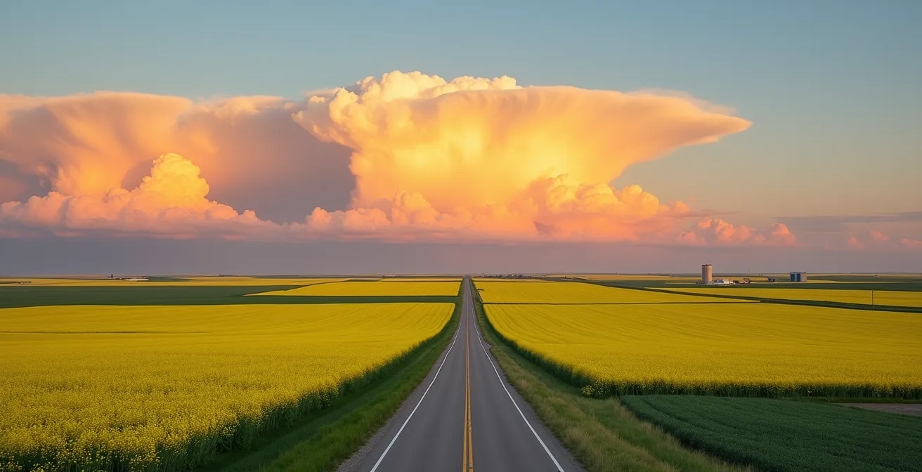
Canola Fields in Bloom: When Is the Best Week to See a Yellow Sea?
In July, the Saskatchewan landscape undergoes a radical transformation. What was a patchwork of green and brown becomes an electrifying sea of brilliant yellow as the canola fields burst into bloom. This is not a subtle event; it is an explosion of colour that redefines the entire visual experience of the drive. The sheer scale of these fields creates an effect of ‘colour flooding’, where the intense yellow light reflects upwards, tinting the undersides of clouds and filling the air with a golden haze. This is the prairie canvas at its most expressionistic. For any traveller wanting to witness this spectacle, timing is everything.
While weather patterns can cause slight variations from year to year, the peak bloom is remarkably consistent. According to Saskatchewan tourism experts, canola fields typically reach peak bloom during the second to third week of July. This is the magic window when the flowers are at their most vibrant, before they begin to drop their petals and form seed pods. A drive down Highway 2 south of Moose Jaw or through the rolling hills around the Battlefords during this period offers one of the most stunning sights in Canada: an endless quilt of brilliant yellow canola, deep blue flax, and golden wheat fields stretching to the horizon.
However, appreciating this beauty comes with a responsibility. These fields are the livelihood of local farmers, and biosecurity is a serious concern. Diseases like clubroot can be spread by soil carried on shoes and tires. Therefore, it is absolutely essential to enjoy the view from the public road shoulders. Never enter a private field for a photo, no matter how tempting. You can capture breathtaking images from the roadside by using the road itself as a leading line into the expanse of yellow. This respectful approach ensures the canola canvas remains a vibrant and sustainable spectacle for years to come.
Red Coat Trail vs. Trans-Canada: Which Drive Offers Better History?
Choosing your route across Saskatchewan is not just a logistical decision; it’s a historical one. The two main east-west arteries, the Trans-Canada Highway (Hwy 1) and the Red Coat Trail (Hwy 13), tell two vastly different stories of the province’s past. The best choice depends entirely on the narrative you wish to explore. The Trans-Canada is the story of modern, 20th-century Canada—a tale of nation-building, commerce, and post-war optimism. It connects the major hubs of Regina and Moose Jaw, offering access to modern amenities and key institutions.
A prime example of this narrative is the RCMP Heritage Centre in Regina, located right off the highway. As Destination Canada highlights, this is a cornerstone of the Canadian story. They state in their guide, “Exploring Saskatchewan: Canada’s land of living skies”:
Every member of the Royal Canadian Mounted Police undertakes their initial training at the training depot in Regina, the provincial capital. The adjacent Heritage Centre tells the story of the force since 1873 and displays historic artefacts, including the rifle case that once belonged to Sitting Bull, the Sioux chief.
– Destination Canada, Exploring Saskatchewan: Canada’s land of living skies
In contrast, the Red Coat Trail to the south is a grittier, more complex narrative of the 19th-century frontier. It roughly follows the 1874 march of the North-West Mounted Police (the precursors to the RCMP) as they moved to establish Canadian sovereignty in the West. This route is less developed and takes you through a landscape that feels older and more untamed. It leads to places like Fort Walsh National Historic Site and the Cypress Hills Massacre site, confronting travellers with the often-conflicted history of colonial expansion and its impact on Indigenous peoples. It’s a slower, more contemplative drive that connects you to the land’s pre-provincial identity.
The choice is not about which is “better,” but which perspective you seek. The table below, inspired by a comparative analysis, breaks down the thematic differences.
| Aspect | Trans-Canada Highway (Hwy 1) | Red Coat Trail (Hwy 13) |
|---|---|---|
| Historical Theme | 20th-century nation-building and post-war optimism | North-West Mounted Police expansion and frontier conflict |
| Key Sites | RCMP Heritage Centre (Regina), modern prairie towns | Fort Walsh National Historic Site, Cypress Hills Massacre site |
| Cultural Perspective | Modern Canadian development story | Complex colonial expansion narrative |
| Recommended Detour | Wanuskewin Heritage Park for Indigenous history | Grasslands National Park for pre-colonial landscape |
Combating Monotony: How to Stay Alert on Straight Roads for 8 Hours?
The greatest challenge of a prairie drive isn’t the distance, but the perceived lack of stimulus. The straight road, the steady rhythm of the engine, and the vast, unchanging horizon can lull a driver into a trance-like state. The conventional solution is passive: listen to music or podcasts. A more effective, artistic approach is active: transform the drive into a practice of mindfulness through sensory scaffolding. This means consciously engaging all your senses to build a richer, more detailed experience of the landscape, turning the drive from a monotonous task into a meditative observation.
Instead of trying to ignore the environment, you lean into it. Create a game, a sensory scavenger hunt. The goal is to notice the small things that break the pattern. Look for the elegant spiral of a Swainson’s hawk catching a thermal. Scan the horizon for the increasingly rare silhouette of a classic wooden grain elevator. When you pass a blooming canola field, open a window and inhale its distinct, sweet-and-peppery scent. At a rest stop, turn off the engine and listen for the flute-like song of the Western Meadowlark, Saskatchewan’s provincial bird. Make it a mission to taste a slice of Saskatoon berry pie at a small-town cafe. This active engagement keeps the mind sharp and connected to the place you’re moving through.
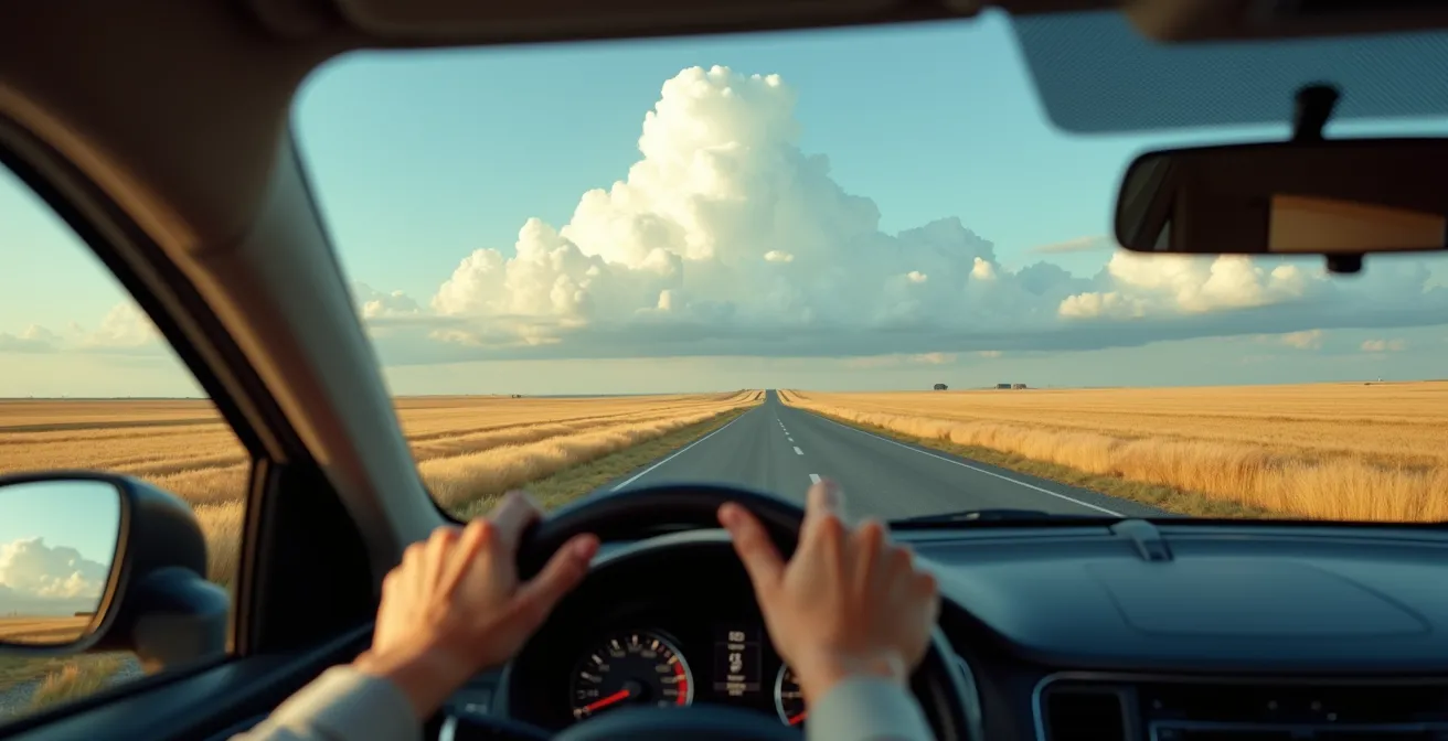
This approach reframes the journey. The endless road, as seen in the image, ceases to be a symbol of boredom and instead becomes a tool for focus—a leading line into a state of calm awareness. The drive is no longer about getting from point A to point B; it becomes a practice in being present. By actively seeking out these sensory details, you are not just staying alert; you are curating your own experience and composing a unique memory of the prairie canvas.
Why Is “Highway Hypnosis” Dangerous on the Prairie’s Straight Roads?
Highway hypnosis, also known as “white line fever,” is a mental state in which a person can drive a vehicle for a great distance, responding to external events in the expected, safe, and correct manner with no recollection of having consciously done so. On the long, straight, and visually repetitive highways of the Canadian prairies, the risk is exceptionally high. The brain, deprived of changing stimuli, can slip into a semi-automatic mode, dangerously close to sleep. The primary danger isn’t falling fully asleep, but experiencing “micro-sleeps.” These are terrifyingly brief, involuntary episodes of sleep that can have catastrophic consequences. An analysis of road trip safety highlights that even brief micro-sleeps lasting 2-3 seconds are long enough for a car travelling at highway speed to drift across lanes or off the road entirely.
On a winding mountain road, the constant need to steer, brake, and accelerate keeps the driver’s brain engaged. On a prairie highway, where you might not touch the steering wheel for kilometres at a time, the executive functions of the brain can begin to disengage. This is compounded by the low visual frequency; there are simply fewer objects moving across your field of vision. The rhythmic hum of the tires on the pavement and the steady drone of the engine act as a powerful, hypnotic lullaby. It’s a perfect storm for mental fatigue, making proactive prevention not just a good idea, but an essential safety measure for any long-distance prairie drive.
The key to prevention is to deliberately and frequently break the monotony. This requires more than just caffeine; it requires cognitive and physical interruptions to reset your brain’s attention. The following checklist provides concrete, prairie-specific strategies to keep your mind active and alert.
Your Action Plan: Prairie-Specific Highway Hypnosis Prevention
- Apply the ‘Grain Elevator Rule’: Force a physical stop to stretch and walk around at every third unique grain elevator you spot.
- Engage Cognitively: Listen to engaging Canadian history podcasts or prairie-themed audiobooks to keep your mind actively processing information.
- Rotate Drivers: Switch drivers every two hours, regardless of whether the current driver feels tired or not.
- Break the Pattern: Set alarms on your phone for random, odd intervals (e.g., 17 minutes, 28 minutes) to jolt your attention.
- Practice Social Engagement: Play the ‘Saskatchewan Wave Game’ by waving at drivers of oncoming vehicles in rural areas (the high wave-back rate provides positive feedback).
Why Is the “Blue Hour” Longer in Northern Canada Than in the Tropics?
The extended, ethereal twilight is one of the most magical qualities of a Canadian prairie summer, a phenomenon rooted in basic celestial mechanics and geography. The “blue hour,” that coveted period after sunset when the sky is awash in deep, saturated blues, is significantly longer in northern latitudes like Saskatchewan’s (around 52°N) than it is near the equator. The reason is the angle at which the sun sets. Near the equator, the sun plunges below the horizon at a steep, almost perpendicular angle. This rapid descent means the transition from light to dark is swift, and the blue hour is fleeting, often lasting only 20-25 minutes.
In Saskatchewan during the summer, however, the sun’s path is very different. It descends at a much shallower, more oblique angle, skimming just below the horizon for a prolonged period. Because it lingers so close to the edge of the world, it continues to illuminate the upper atmosphere long after it has disappeared from view. This lingering, indirect sunlight is what creates the extended blue hour. The light has to travel through a vast amount of atmosphere, which scatters away the warmer red and yellow wavelengths, leaving only the deep, cool blues and violets to paint the sky. This unique geographic position provides photographers and sky-gazers with an exceptionally long and forgiving window to witness one of nature’s most beautiful light shows.
This stark difference in twilight duration is not just a feeling; it’s a measurable fact. The following table clearly illustrates the photographic advantage that Saskatchewan’s latitude provides.
| Location | Latitude | July Blue Hour Duration | Sun Angle at Sunset |
|---|---|---|---|
| Saskatoon, Saskatchewan | 52°N | 45-50 minutes | Shallow (gradual descent) |
| Quito, Ecuador | 0° (Equator) | 20-25 minutes | Steep (rapid plunge) |
| Photography Advantage | Longer blue hour = more forgiving window for landscape photographers | ||
This extended twilight is the essence of the “Living Skies.” It’s a gift of geography, turning every summer evening into a potential masterpiece of atmospheric colour.
Key takeaways
- The beauty of the Saskatchewan prairie is not in specific sights, but in understanding the landscape as a whole: a canvas for light, colour, and atmosphere.
- The province’s northern latitude and flat horizon create unique optical effects, like exceptionally long and vivid sunsets and blue hours, that are scientifically distinct.
- Engaging the drive as an active sensory experience, rather than a passive one, is the key to both safety (combating highway hypnosis) and appreciation.
Farm Stays in Manitoba: How to Disconnect Digitally for a Weekend?
After immersing yourself in the vast skies of Saskatchewan, the journey eastward into Manitoba offers a perfect opportunity to transition from observing the landscape to living within it. A farm stay is the ultimate expression of this immersion, providing a powerful antidote to the digital noise of modern life. The goal of a digital disconnect on a Manitoba farm isn’t about deprivation; it’s about replacement. You replace the artificial stimulus of a screen with the rich, grounding rhythms of the natural world and agricultural life.
The process of disconnecting happens almost automatically. Firstly, many rural farm stays in regions like the Interlake or Pembina Valley have naturally spotty cell service, removing the temptation of constant connectivity. This isn’t an inconvenience; it’s the first step of the cure. Secondly, the farm environment demands your physical and mental presence. Helping with simple chores, like feeding animals, tending a garden, or mending a fence, grounds you in the tangible world. The satisfaction comes from completing a physical task, not clearing a notification badge. The sensory inputs are real: the smell of hay, the warmth of the sun, the texture of soil.
The true disconnect, however, comes from aligning your personal rhythm with the farm’s. You wake with the sun, not an alarm. Your day’s activities are dictated by the weather and the needs of the land, not a digital calendar. Evenings are spent watching the stars emerge in a sky free from light pollution, not staring at a blue-lit screen. This recalibration is profound. It slows your thoughts, deepens your appreciation for where food comes from, and reconnects you to a more fundamental way of being. In Manitoba, organizations promoting agritourism can help connect you with host farms that offer this authentic experience, allowing you to truly power down and recharge your own spirit.
Now that you are equipped with an artist’s eye for the prairies, the only remaining step is to begin your journey. Plan your drive for that magic window in July, choose the historical narrative you wish to follow, and commit to seeing the endless horizon not as an obstacle, but as the main attraction.